
Tuesday, 4th February 2013: It seems to me that one of the potential problems with Democracy is that the majorities can make life difficult for minorities. In business there are Shareholder Rights that in part protect minority shareholders when majority shareholders seek to act in way that is unfairly prejudicial to their interests. It is also known as shareholder oppression.
In politics one might see it as one County or City Council making decisions that affect another County or City Council. Here in the flatlands we have already seen that with the A14 upgrade:- “We won’t pay for the A14 upgrade, city council says”. The City of Cambridge is already badly congested, “improving” the A14 is likely to increase the congestion in and around the city rather than anything whilst from a County Council point of view speeding up the flow of vehicles into and through the county might be seen as a good thing!
I think that the same issues can occur when considering the issues/needs of city dwellers versus those living in the countryside. There are huge trade-offs in terms of living and working. Transport in the country can be more expansive, daily life can be more expensive, but country dwelling can be more tranquil and houses can be cheaper. Apparently around four fifths of the UP population live in cities and towns and I guess that is because of the economics of urban life.
To deal with the issue of creeping urbanisation we have the concept of the Green belt in the UK. As you might imagine whilst the original idea was to resist urbanisation of the countryside a lot depends upon the rules, which change with the different hues of government. The most recent change was the National Planning Policy Framework in March 2012.
There is pressure on the Green belt around Cambridge – as evidenced by the organisation of a group – Save The Cambridge Greenbelt. For more on what can happen here is an article from Cambridge Past, Present and Future comparing Cambridge with Oxford. Here is the South Cambs 2002 study and map.
There are already skirmishes with greenbelt land near Wort’s Causeway under pressure. We also have the National Trust trying to create a 53 square kilometre nature reserve for wildlife and people in Cambridgeshire. (Note the NT seem to have deprecated their Wicken Fen website but it still pops up with missing links, this link is on the main NT website.)
So why all this rambling, well I have just learnt about the Reach Community Solar Farm. Reach is an interesting and quite rural village on the edge of the Fens with a rather nice pub – The Dyke’s End. I’d recommend it and no I don’t get my beer cheap for saying so (or anything else.)
At first look it would seem that it is a balanced approach, a moderate amount of land, seeking subscription from the village and set up as an Industrial and Provident Society for the Benefit of the Community. So why the fuss, well there has surfaced another proposal for a 250 acre Solar Farm on the edge of the village, by a company called Solar Associates. For a better comparison of the scale of the two operations here is a Reach website link.
As you can see it will be pretty big – and virtually surround Tubney Fen. It will also be much larger than the village itself. Now I do believe that the UK needs to become less dependant on imported energy for economic reasons and less dependant on carbon-based energy for ecological reasons.
So how to weigh up the various issues? I think that there is a tendency to look at Wind turbines and consider them as being rural-friendly, in that the footprint is relatively small and crops can and are grown around them. For instance the Wadlow Wind Farm has 13 turbines and is rated as a 26MW wind farm capable of generating the annual requirements of nearly 17,000 homes. There is an aerial picture of the Wind Farm in this item from Bidwells which show how much of the farm land is still available. According to this article in Wikipedia the land use of a wind farm ties up 1% of the area it sits in allowing the remainder to continue for agricultural use. (Of course they are generally visible for miles in all directions and can create flicker and noise).
Using the Wadlow Wind Farm as an example, an annual payment of £39,000 will also be paid into the Wadlow Wind Farm Community Fund for assistance and support to local projects, events and good causes.
By comparison the Solar Associates Solar Farm Proposal will generate 45Mwatts and occupy around 104 hectares (257acres) of which little will be left for agriculture judging from this picture of a Solar Farm development at Wilburton. (Apparently you can graze livestock around them!) The last link also mentions the issue of getting Solar Farm proposals in early to ensure a grid connection – so the proximity to the Burwell Electricity sub-station is probably one of the reasons that is driving the Solar Associates Solar Farm Proposal.
According to this website a rough estimate indicates that each MW of capacity costs around £1m - £1.2m and take up to 2 –3 hectares of land. The life span of the Solar Farm would be 30 - 35 years.
Under normal circumstances you would imagine than any plan to build an industrial park on 250+ acres of good farmland in the countryside would get short shrift. Especially one with such public amenity (Wicken Fen Vision), with the Lodes Way and various feeder routes. It runs adjacent to Headlake Drove and Split Drove, it surrounds Tubney Fen.Trucking in the construction materials sounds like a huge undertaking. Although there is a discrepancy, the Planning submission for the Environmental Impact suggests it will use 13,000 panels for 45MW whilst the Wilburton Solar Farm data indicates that it used 21,700 solar panels for a 5MW capacity. Which suggests that there is a typo and that perhaps it will require 130,000 panels. Wilburton – 5MW/ 21,700 panels implies 230W/panel, Solar Assoc – 45MW/ 130,000 panels – 346W/panel.
So I reckon that 130,000 panels sounds about right to me. The proposal suggests that 1,000 Inverters will be needed. So assuming the one lorry can carry, say 20 panels per trip then there will need to be 6,500 deliveries - that doesn’t include the metalwork and all the pilings. Whilst the proposal suggests that the footings won’t need to be anything special checkout the way the roads along the fens undulate because of soil shrinkage and the telegraph poles lean. So it could easily mean 10,000 lorry trips – 200 per week, 40 per working day, or one every 12 minutes of an 8 hour day. The roads will have to be reinforced to make it happen. A few tractors running up and down rip them to pieces.
As it is the area already has the blight of the Sub-station and two sets of pylons running over the land crackling away when it rains. A quick check on Google and did you know that 250 acres is the equivalent of over 14o football pitches – serious blight. Perhaps their strategy is to go in way over the top expecting the project to be pegged back and then end up with say a 50 or 100 acre project which was the intention all along.
So I come back to my question at the start of my post are the minority – are those in Reach and the surroundings being treated fairly compared with the majority – I think the answer is no. This is not a brownfield site this is an area of natural importance. If it goes ahead I think it it will completely change the character of the place.
Apparently a much smaller Solar Farm planned for the gateway to the Norfolk Broads has been withdrawn – “Joy as three major solar farm plans are withdrawn”.
Yes I know I probably feel stronger than many about the area as it is one I cycle around frequently. Well this ride took me along Lodes Way, up to Upware and back via Wicken Fen. Again I took my long lens with me and only selected a few pictures for my blog.
I didn’t do a lot of processing of the pictures to get the monochrome look - that is the way they came out.
Wicken Lode

Wicken Lode

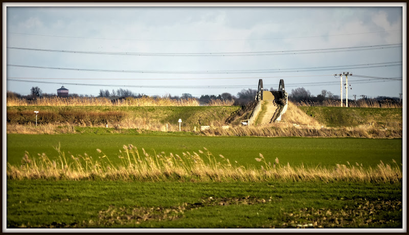
Reach Lode Bridge from Headlake Drove – take a look now – this view could get blocked. Notice the old Soham Water Tower in the background. Apparently the screening around the Solar Farm would be block the view of the 2.4m high panels – so 3m? (9ft). In the flat lands any screening is significant.
Reach Lode Bridge – a great view – but for how much longer?
Humungous Solar Farms belong on brownfield sites.
Like your blog. great photos: what camera do you use?
ReplyDeleteHi Nigel,
DeleteSorry for the delay in replying - I mainly use a Panasonic Lumix GH1 for my cycling, mostly with a 14-140 zoom, but occasionally with a 100 - 300mm lens (as was used for these pictures.) I find the Micro Four Thirds System is a good compromise for photography on cycling trips. (I have a Sony compact - DSC-W200, when I am working, but increasingly rely on my Samsung Galaxy S4 when I haven't got my GH1
I also use HDR software from HDRsoft called Photomatix, although I am trying to use it more subtly than I used to.
---Jamie